Large Scale Manure Farms Threaten Lake Superior and area communities Red Cliff Scoping Comments Bad River Scoping Comments Source Water Assessment For Ashland WI Water Utility
Bill Clark
Environmental Review Supervisor
DNR Service Center
810 W. Maple Street
Spooner, WI 54801
Subject: EIS Scoping Comments on the Badgerwood LLC, CAFO
Dear Mr. Clark,
This letter is to provide comments to the Wisconsin Department of Natural Resources (WDNR) regarding the scope of the Environmental Impact Statement (EIS) for the proposed Badgerwood project in the Town of Eileen in Bayfield County, Wisconsin.
As you know, the Great Lakes Fish and Wildlife Commission (GLIFWC) is an intertribal agency exercising delegated authority from 11 federally recognized Ojibwe (or Chippewa) tribes in Wisconsin, Michigan, and Minnesota. Those tribes have reserved hunting, fishing, and gathering rights in territories ceded in various treaties with the United States. GLIFWC’s mission is to assist its member tribes in the conservation and management of natural resources and to protect the habitats and ecosystems that support those resources.
GLIFWC previously wrote a letter to WDNR urging them to prepare an EIS for this project and we are pleased that they have agreed to do so. We offer these comments to assist WDNR in conducting a thorough review of the potential impacts of the proposed Badgerwood LLC project.
Comment on the Permitting Process.
GLIFWC is providing comments on the scope of the EIS to the best of our ability at this time.
However, it is our understanding that the Badgerwood WPDES application remains incomplete.
According to the WDNR web site (http://dnr.wi.gov/topic/AgBusiness/CAFO/Badgerwood.html,
Accessed September 28, 2015), the application is incomplete, and “aspects of the proposal may
change when the application is complete since a wetland delineation has not been completed.”
September 30, 2015
GLIFWC Badgerwood EIS Scoping Comments September 30, 2015
We reserve the right to provide additional scoping comments pending the completion of the wetlands delineation and if any changes to the application are made.
Environmental Quality of the Proposed Project Location
The area surrounding the proposed Badgerwood project is recognized as an exceptional
environmental resource, as demonstrated by the numerous special habitat designations in place.
Many of these designations call for the implementation of special protections, including some
dictated by state law (e.g., Wisconsin Administrative Codes NR 102 and NR 207). The critical
importance of the environment and natural resources of the area most likely to be impacted – the
Fish Creek and White River watersheds, as well as Chequamegon Bay – is demonstrated by the
multitude of protected areas and special designations that have been put in place, including:
- The Bayfield Regional Conservancy’s 2009 Strategic Conservation Plan for Lake Superior’s Bayfield Peninsula names the Fish Creek watershed a Priority Conservation Area (PCA). PCAs are defined as areas where several high quality conservation values (e.g., wildlife habitat, water quality, rare species, scenic features, and wetlands) overlap with one another creating a “hot spot” for conservation. Of the 13 watersheds within Bayfield County, the Fish Creek watershed received the highest score for “Conservation Significance.” Identification of Fish Creek as a PCA was based on its rich array of habitats, fish spawning and nursery areas, rare plant communities, and diversity of aquatic plants, waterfowl, and fish.
- The Lake Superior Special Designation Work Group, a diverse stakeholder group organized in 1998 by former Wisconsin governor Tommy Thompson, decided by consensus that “Lake Superior is special, sensitive, and unique and deserves a special designation.” In 2002 the Work Group developed a Tier 1 category that established a no- discharge zone within one-quarter mile around river mouths and the Apostle Islands. This measure aims to protect critical spawning beds in the lake, which tribal commercial fisheries depend upon, and includes areas within Chequamegon Bay.
- The Fish Creek Sloughs have been designated a priority wetland site by the State of Wisconsin and provide important wildlife and fish habitat. This area is used heavily by waterfowl, gulls, terns, and shorebirds. Uncommon birds have been documented in this area during the breeding season. The sloughs provide spawning habitat for northern pike and nursery habitat for nearly all of the warm-water fish species in Chequamegon Bay. Twenty-nine species of reptiles occur in the Fish Creek slough, including the state threatened wood turtle.
- The area includes many sites identified on the Lake Superior Binational Program’s map of Important Habitat in the Lake Superior Basin, including the North Fish Creek watershed, Whittlesey Creek National Wildlife Refuge, and Chequamegon Bay and its connected resources (e.g., the Kakagon-Bad River sloughs). These locations are shown on the excerpt from the map below.
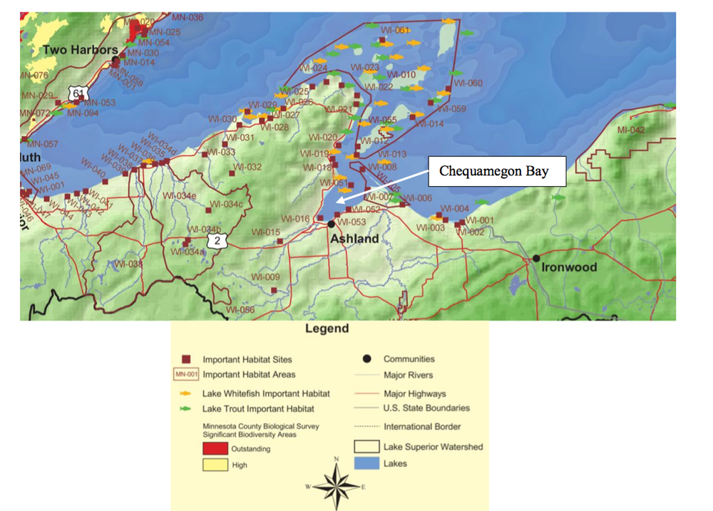
Chequamegon Bay
5. The Kakagon-Bad River Sloughs complex is a Wetland of International Importance, also designated as a Ramsar site. The diversity of wetland types in the sloughs contributes to its unique and rare features, such as vast beds of wild rice, spawning habitat for lake sturgeon, and stopover habitat for numerous migratory birds. Comprising a significant portion of the remaining Lake Superior coastal wetlands, the Kakagon-Bad River Sloughs complex is critical to supporting the biodiversity of Lake Superior fisheries. The sloughs have received numerous designations and recognitions, including, but not limited to, an Outstanding Tribal Resource Water (or Tier 3 water), and National Natural Landmark. This vast coastal ecosystem is comprised of unique and diverse habitats and species and supports critical regional functions, such as walleye spawning.
6. The area likely to be impacted by the proposed Badgerwood project contains a large number of state designated Outstanding and Exceptional Resource Waters (ORW/ERW, Wisconsin Administrative Code NR 102). These are the state’s highest quality waters, which have not been significantly impacted by human activities. The ORW/ERW status identifies waters that the State of Wisconsin has determined warrant additional protection from the effects of pollution and are subject to the state’s “antidegradation” policy (Wisconsin Administrative Code NR 207), which is designed to prevent any lowering of water quality in waters of significant ecological or cultural significance. The Fish Creek watershed contains 8.5 miles of perennial ORW/ERWs, including Fish Creek and North Fish Creek. The White River is designated as a state ERW. The waters of Lake Superior surrounding the mouth of Fish Creek and the Apostle Islands National Lakeshore are designated ORWs.
7.Many waters in the area likely to be impacted by the proposed Badgerwood project are
high quality trout waters. This includes North Fish Creek, which has been designated a Class I Trout Water by the state, the highest possible classification. In addition, the White River has been designated a Class II Trout Water.
8. The Whittlesey Creek National Wildlife Refuge includes 100 acres bordering Terwillinger Creek, which is located in the Fish Creek watershed downstream of the proposed CAFO. Whittlesey Creek is designated an Outstanding Resource Water by the State of Wisconsin. The refuge was established in 1998 in an effort to restore coaster brook trout, a native trout that spawns in Whittlesey Creek and spends its adult life in Lake Superior. Salmon and other fish species also spawn in this creek.
9. The National Audubon Society designates certain places as Important Birding Areas (IBAs). An IBA is a site that provides essential habitat to one or more vulnerable bird species and is distinguishable in character, habitat, or ornithological importance from surrounding areas. Wisconsin has 88 IBAs, several of which lie in areas with the potential to be impacted by the proposed Badgerwood project. These areas include Lower Chequamegon Bay, the Kakagon-Bad River Wetlands-Forest Corridor, and the Apostle Islands National Lakeshore.
10. The Frog Bay Tribal National Park is located on the shores of the Red Cliff Reservation. Although Frog Bay is located just outside of Chequamegon Bay, currents in the Bay often travel in a counterclockwise circulation. Thus, Frog Bay (along with the Red Cliff Reservation’s 22 miles of pristine shoreline) may be impacted by inputs from Fish Creek.
The EIS should identify any potential impacts from the project on these and other critical areas, determine how these impacts will affect the special habitat designations, and discuss any conflicts with management goals or laws applying to these areas.
Conflicts with Existing Plans and Initiatives
According to federal regulations [40 CFR 1502.16 (c)], a proposed action’s EIS must include a
discussion of “possible conflicts between the proposed action and the objectives of federal,
regional, state, and local land use plans, policies and controls for the area concerned.” It is
further stated in 40 CFR 1506.2 (d) that “to better integrate environmental impact statements into
state or local planning processes, statements shall discuss any inconsistency of a proposed action
with any approved state or local plan and laws (whether or not federally sanctioned). Where an
inconsistency exists, the statement should describe the extent to which the agency would
reconcile its proposed action with the plan or law.” Wisconsin statute 1.11(2)(c) requires that all
Wisconsin agencies considering environmental impacts follow these federal guidelines, as
mandated under the National Environmental Policy Act (NEPA).
The proposed Badgerwood project has the potential to increase agricultural runoff and inputs (e.g., nutrients) to the Fish Creek and White River watersheds and ultimately Lake Superior’s Chequamegon Bay. As a result, the proposed CAFO may be in conflict with numerous plans and initiatives due to likely negative impacts on water quality, habitat, or other aspects of the environment. This includes, but is not limited to:
- The Fish Creek Watershed Restoration and Management Plan was completed in 2011 by the Ashland County Land and Water Conservation Department (http://www.northland.edu/wp-content/uploads/2015/07/FishCreekManagementPlan.pdf). The CAFO itself and the majority of the fields used for manure spreading are located within the Fish Creek watershed. Watershed objectives set forth in this Plan include reducing agricultural runoff from the clay plain uplands to watershed drainages and waterways.
- In 2013, the Wisconsin DNR published the White River Property Group Master Plan (DNR PUB-LF-072, http://dnr.wi.gov/files/PDF/pubs/lf/LF0072.pdf). The Badgerwood project also proposes manure spreading on fields within the White River watershed. Goals of the Plan include protecting the outstanding game fisheries, preserving the cold riverine habitat, promoting quality habitat, and maintaining the existing Outstanding/Exceptional Resource Waterway (ORW/ERW) designations in the area. The Plan recognizes that excessive nutrient inputs “degrade in-stream habitats and diminish efforts to sustain a high quality, self-sustaining trout fishery.”
- Anti-degradation is a guiding principle of the 2012 Great Lakes Water Quality Agreement (http://binational.net/wp-content/uploads/2014/05/1094_Canada-USA- GLWQA-_e.pdf), with the goal of maintaining or improving water quality in the waters of the Great Lakes. A general objective of the Agreement is that the Great Lakes “be free from nutrients that directly or indirectly enter the water as a result of human activity, in amounts that promote the growth of algae and cyanobacteria that interfere with aquatic ecosystem health or human use of the ecosystem.” The specific Lake Ecosystem Objective for Lake Superior calls for “maintaining an oligotrophic state, relative algal biomass, and algal species consistent with healthy aquatic ecosystems.” Nutrient inputs to Chequamegon Bay as a result of the proposed CAFO have the potential to result in algae blooms and dead zones, and to alter the current oligotrophic state of these waters.
- The Great Lakes Restoration Initiative was launched in 2010 to protect and restore the Great Lakes. The 2014 Great Lakes Restoration Initiative Action Plan II (http://www.greatlakesrestoration.us/actionplan/pdfs/glri-action-plan-2.pdf) includes “reducing runoff that contributes to algal blooms” as one of its four major focus areas in order to reduce nonpoint source pollution impacts on the nearshore heath of the Great Lakes.
- The 2008 Lake Superior Lakewide Management Plan (http://epa.gov/greatlakes/lamp/ls_2008/ls_2008.pdf) contains ecosystem goals related to climate change and nutrients that may be in conflict with potential methane releases and nutrient runoff from the proposed Badgerwood CAFO. Specifically, the Plan calls for “making Lake Superior a net carbon reduction area that reduces greenhouse gas emissions” and “protecting oligotrophic conditions in nearshore and offshore waters and restoring and protecting water quality in embayments and tributaries.”
- The 2015 Lake Superior Biodiversity Conservation Strategy (http://www.natureconservancy.ca/assets/documents/on/A-Biodiversity-Conservation- Strategy-for-Lake-Superior.pdf) recognizes that nutrient runoff is a threat to existing high-quality habitats. The Strategy calls for “protecting oligotrophic conditions (i.e. high in oxygen, low in nutrients) in nearshore and offshore waters, and restoring and protecting water quality in ebayments and tributaries.”
7. The Bayfield County Comprehensive Plan Update 2010 (http://www.bayfieldcounty.org/DocumentCenter/Home/View/129) identified the natural environment as one of the county’s key strengths and names threats to water quality one of the county’s biggest concerns. Water quality protection and the preservation of natural resources (including surface and groundwater) are named as priorities. According to the county’s vision statement, “Natural resources will be protected and serve as an environmental, recreational, and economic asset to the county. Development will be compatible with the natural environment to ensure these resources are protected for future generations.” A goal is set forth in the Plan to “conserve, protect, manage, and enhance the county’s natural resources, including but not limited to lakes, rivers/streams, wetlands, groundwater, forestlands, and other wildlife habitats in order to provide the highest quality of life for citizens and visitors.” The Plan states that the county will consider the preservation of natural resources in the decision making process for all planning and development decisions with the goal of ensuring that all land use and development is “compatible and harmonious with the natural environment.”
8. In February 2015, The Bayfield County Board approved a 12-month moratorium on CAFOs, with the option to extend the moratorium for an additional six-months if needed to assess the potential impacts of allowing a CAFO in the region. Other local counties have similar concerns. Iron County passed a similar moratorium in March 2015 and Ashland County is exploring a two-year moratorium on CAFOs.

9. The Town of Eileen, WI Comprehensive Plan (2010) (http://www.townofeileen.com/images/EileenPlanSummary.pdf) does not include increasing agriculture within the town. The plan states the town will ensure that its rivers and streams are protected; promote a high level of environmental quality of lands, water, and wildlife habitat; discourage land use practices that have a detrimental effect on the land, soil, or air quality of the town; and maintain safe, quality drinking water.
10. The first of the five goals laid out in the Bayfield County Land and Water Resource Management Plan 2010-2020 (http://www.bayfieldcounty.org/DocumentCenter/View/1058) is to “protect and enhance surface water, wetlands, and groundwater to maintain water quality, ecologic function, and recreation and aesthetic values.” Specifically, the plan calls for reducing and mitigating surface and groundwater impacts from agricultural land use activities.
11. The Chequamegon Bay Area Partnership’s Strategic Priorities (2013, http://www.northland.edu/assets/files/SOEI/CBAP.Strategic.Priorities.2013.Final.pdf) identifies reducing pathogen (bacteria) and nutrient levels in the Bay area as a strategic priority.
12. The WDNR’s 2005 Strategy for Wildlife Species of Greatest Conservation Need (SGCN) (http://dnr.wi.gov/files/PDF/pubs/ER/ER0641.pdf) calls for the “protection of unique Great Lakes shoreline environments, such as the vast Bad River-Kakagon Sloughs and the smaller but biologically rich estuaries at Fish Creek.” The Fish Creek watershed is home to 11 SGCN.
13. The Fish Creek watershed contains 8.5 miles of perennial Outstanding or Excellent Resource Waters (ORW/ERW, Wisconsin Administrative Code NR 102). In addition, the White River is designated as a state ERW. Therefore these waters are subject to Wisconsin’s “antidegradation” policy (Wisconsin Administrative Code NR 207), which is designed to prevent any lowering of water quality in waters of significant ecological or cultural significance. Any increased discharges to these waters as a result of the proposed Badgerwood project would be in conflict with this policy.
14. The guiding principle of the Bad River Tribe’s Integrated Resource Management Plan
(2001) is based on the management of all natural resources using an ecosystem approach to maintain or improve the water quality of all surface and groundwater resources within the Reservation and within the larger watersheds of which the Reservation is a part. The Plan, recognizing their importance to the community for subsistence resources (e.g., fish, wild rice) as well as cultural and spiritual value, designates the Kakagon-Bad River Sloughs complex as a Conservation Area. Inputs and runoff from the proposed Badgerwood project have the potential to reach these critical areas once they enter Chequamegon Bay from Fish Creek or from the White River, a major tributary to the Bad River.
15. The Red Cliff Integrated Resource Management Plan (http://redcliff- nsn.gov/Planning/RC_IRMP.pdf) stresses the importance of maintaining water resources, including Lake Superior, in “excellent condition.” The plan recognizes the importance of the tribe’s coastal wetlands as “unique and beautiful places that are crucial to the ecosystem of the reservation and the region. The restoration, management, and protection of wetlands are crucial components in maintaining a healthy environment for Red Cliff.”
16. The Apostle Islands National Lake Shore General and Wilderness Management Plan’s (2011, http://www.nps.gov/apis/upload/APIS-GMP-short-version.pdf) strategies for natural resource management incorporate an ecosystem approach that reaches beyond the boundaries of the park. The Plan recognizes that “activities that occur outside the park affect, sometimes profoundly, the Park Service’s ability to protect natural resources inside the park.” The Plan includes a water quality goal that “all human sources of water pollution, both within and outside the park, that are adversely affecting the Apostle Islands National Lakeshore are eliminated, mitigated, or minimized.”
The EIS must evaluate the impacts of the proposed Badgerwood project relative to the objectives of these and any other plans or initiatives in the project area, and identify and reconcile any conflicts between the project and the existing plans. All of these plans are based on the common themes of protecting and improving the local environment and assuring that any development or land use will not have a detrimental effect on natural resources. The EIS should determine the extent to which any nutrient, bacteria, or other inputs into the environment from the Badgerwood project would eventually enter the Fish Creek watershed, the White River watershed, Lake Superior or any other waters.
Treaty Resources and Obligations
The WDNR must include in the EIS an evaluation of the potential impacts of the proposed
Badgerwood project on the treaty reserved resources within the proposed project’s watershed and
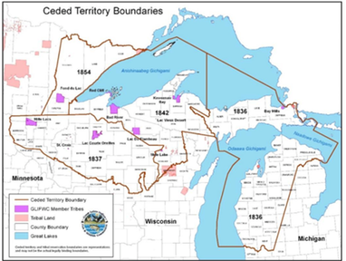
other impacted areas. The proposed project lies within the 1842 ceded territory, which includes
portions of Lake Superior and its watershed (see the map below). This territory was ceded by the
member Tribes of the Great Lakes Indian Fish and Wildlife Commission to the United States in
the Treaty of 1842 (7 Stat. 591), in which they also reserved their hunting, fishing, and gathering
rights to guarantee they could continue their way of life (or “lifeway”) in a manner that meets
their subsistence, economic, cultural, medicinal, and spiritual needs. These rights necessarily include co-management authority over the resources to ensure a healthy, sustainable resource
base to support their hunting, fishing, and gathering rights. Reserved by treaty, these rights have
been repeatedly affirmed by federal courts.
Treaties are the supreme law of the land, and the affirmation of the Tribes’ roles as co-managers within the ceded territories places an added onus on the State to undertake true government-to- government consultations with potentially affected Tribes so that it can understand and properly account for the proposed project’s potential impacts on their rights and their members’ ability to harvest clean and healthy natural resources from the ceded territories. An evaluation of these impacts must then be included in the EIS to show that the potential impacts on the treaty resources have been properly considered.
The proposed project has the potential to significantly impact multiple Lake Superior tributary watersheds (i.e., Fish Creek and White River) in which the Tribes hold treaty rights, as well as the potential to impact Lake Superior. GLIFWC member Tribes understand that clean water is fundamental to life. They regard it as “the first medicine” and as the blood of their mother, the earth. GLIFWC member Tribes also believe that actions affecting natural resources must be judged on how well they will protect seven generations hence and seek to ensure that principles of ecosystem management and biological diversity recognize and protect the fundamental interdependence of all parts of the environment. The State must account for the impacts of the proposed project on the treaty rights of GLIFWC’s member Tribes. Treaty reserved rights bar the State from unilaterally undertaking actions that might impact those rights, and the State lacks the discretion to issue permits or make management decisions unconstrained by the existence of those rights.
RCRA and Solid Waste
The applicant proposes to spread nutrients on fields above levels that can be utilized by crops.
Over application of nitrates and phosphorous contribute both surface and groundwater
contamination. Over application of these nutrients to fields endangers the environment and may
violate the Resource Conservation Recovery Act (RCRA) with respect to illegal disposal of solid
waste. A recent court decision, Community Association for the Restoration for the Environment
vs. Cow Palace (http://www.centerforfoodsafety.org/files/320--order-granting-in-part-msj-
11415_78926.pdf), concluded that manure is subject to RCRA solid waste regulations and is
considered a solid waste when it can’t be utilized in the environment. They further found that
improper handling, storage, and disposal of manure constitute an imminent and substantial
endangerment to human health and the environment and violate RCRA’s ban on “open
dumping.”
Excess phosphorous applied to fields that is not utilized by the crops will either runoff into waterways or build up to excessive levels in the soil until it eventually reaches the groundwater. Contaminated groundwater is a threat to local residents utilizing wells for drinking water and may impact Lake Superior, an exceptional environmental resource and the source of drinking water for the City of Ashland. The EIS must clearly describe how the proposed project complies with RCRA requirements. In addition, the EIS must describe all water quality impacts of the project. While the applicant must demonstrate that its proposed project will comply with all applicable state and federal standards, the EIS must describe all water quality impacts whether they meet standards or not.
Water Quality: Compliance with Bad River Tribe’s Water Quality Standards
The Bad River Tribe obtained program authority under Clean Water Act Sections 303(c)/401 in
June 2009. The Bad River Tribe approved WQS in July 2011 that apply to the waters within the
exterior boundaries of the Bad River Reservation. Further, these WQS must be met for a
waterbody at the point the surface water enters the Reservation. The WQS were approved by
U.S. EPA in September 2011. The Kakagon-Bad River Sloughs complex and the downstream
portion of the White River are examples of waters to which the Bad River Tribe’s WQS apply.
The WDNR should collaborate with the Bad River Tribe’s NRD and federal entities (e.g., EPA) to assess if the Bad River Tribe’s WQS will be met as a result of the potential impacts from the proposed Badgerwood project.
Surface Water Quality: Accurate Mapping of Surface Water
Accurate mapping of all surface waters (e.g., perennial streams, intermittent streams, ephemeral
streams) and the connectivity between them is necessary to evaluate the potential impacts of
Badgerwood’s manure application and facility construction/operation on surface waters and to
identify alternatives to and gaps in the proposed project plans. The EPA has concluded that “the
scientific literature unequivocally demonstrates that streams, regardless of their size and
frequency of flow, are connected to downstream waters and strongly influence their function”
(U.S. EPA, January 2015. Connectivity of Streams and Wetlands to Downstream Waters: A
Review and Synthesis of the Scientific Evidence. EPA/600/R-14/475F. www.epa.gov/research).
Therefore, all waters of the United States in the area of the potential effects from this project must be identified to properly assess impacts. In addition, verification of digital hydrography data through ground truth methods is required to define all points of compliance for applicable water quality standards.
Field verified mapping of hydrologic features (including wetlands) will allow accurate identification and characterization of the restrictions required to protect surface waters during the field application of manure or process wastewater. These restrictions include, but are not limited to: setbacks from navigable waters, conduits to navigable water, and wetlands; restrictions to the type of manure application process used within Surface Water Quality Management Areas (SWQMA) and near the water resources; buffer areas near the water resources within the SWQMA; and application rate restrictions (NR243.14(4)).
Surface Water Quality: Existing Conditions
The current conditions of surface waters that may be potentially impacted by the proposed
Badgerwood project need to be defined through comprehensive baseline water quality gathering
programs. The EIS must describe the current water quality conditions for surface and
groundwater and disclose whether these waters are meeting their designated uses as defined in
the Clean Water Act (CWA).
The EIS should use all available water quality data and identify gaps in the data set. Surface water data should be collected as necessary to evaluate the current conditions of surface waters and determine if the surface waters are currently meeting the applicable designated uses.
Increased loadings (e.g., nutrients, ammonia, pathogens) to surface waters and associated cumulative impacts are a primary concern associated with CAFOs. Agricultural activity (e.g., crop production, grazing, and animal farming operations) is the top source of impairment in rivers and streams assessed across the nation, causing over 35% of impairments, and is one of the top sources of impairment in assessed lakes (U.S. EPA, Jan. 2009. National Water Quality Inventory: Report to Congress, 2004 Reporting Cycle. EPA 841-R-08-001. www.epa.gov/305b).
The pollutants most commonly associated with manure include nutrients (particularly nitrogen and phosphorus), ammonia, oxygen-demanding substances, pathogens, solids, salts, trace metals, antibiotics, pesticides, and hormones (U.S. EPA. Potential Environmental Impacts of Animal Feeding Operations. http://www.epa.gov/agriculture/ag101/impacts.html. Accessed: 9/22/15). Baseline surface and groundwater data collection should include these parameters.
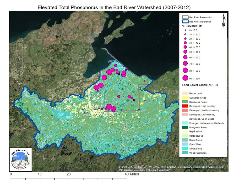
The Bad River Natural Resource Department has been monitoring total phosphorus concentrations at over 35 stream monitoring stations in the Bad River Watershed. Elevated phosphorus is already a concern at multiple at monitoring stations, including locations in the Marengo River watershed and the Beartrap Creek watershed. Often, the monitoring stations with the most exceedances of the total phosphorus threshold (0.075 mg/L) are located downstream of small-scale agricultural practices, as shown in the Figure below. An evaluation of increased nutrient loading to streams as a result of the proposed large-scale concentrated agricultural operation is critical to prevent further degradation of surface waters in the Chequamegon Bay area. This cumulative effect analysis is an important part of an EIS and the data exist to develop a quantitative cumulative effects water quality assessment for this proposed project.
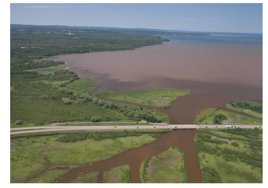
Research by Dr. Randy Lehr, an environmental science professor at Northland College (Ashland, WI), has demonstrated that phosphorous levels in Fish Creek are already excessively high and likely exceed state water quality standards. High phosphorous in the creek sediments are washed directly into Chequamegon Bay, increasing the risk of algae blooms, dead zones, fish kills, and E. coli outbreaks. Fish Creek delivers over 1,000 dump truck loads of sediment to the Bay each year (http://www.northland.edu/sustain/soei/cbap/). The photo below shows the plume of sediments entering Chequamegon Bay following a rain event in 2012 (Photo credit: Northland College). Severe storms, carrying even more sediments into the Bay, are expected to become more common with climate change.
The proposed Badgerwood project may result in an increased risk to human health at Lake Superior beaches due to fecal contamination entering surface waters. In both 2013 and 2014, almost half of the days within the swimming season at Ashland’s Maslowski beach had an advisory or closure issued due to E. coli concentrations exceeding the water quality criteria (Data retrieved from Wisconsin Beach Health website in June 2015. http://www.wibeaches.us/). The impact of the proposed project on the frequency and severity of beach closures must be quantitatively assessed in the EIS.
The EIS needs to contain quantitative assessments of the potential increase in loadings to the surface waters and sediments due to the proposed Badgerwood project. Each of the potential pollutants associated with manure (e.g., nutrients, ammonia, oxygen-demanding substances, pathogens) and other constituents associated with the construction and operation of the proposed Badgerwood project should be evaluated. This assessment should include both the increase in chemical loading to surface waters and increases in sedimentation. Both short term and long term potential impacts should be quantified.
As required by NEPA, the EIS must detail a wide range of alternatives that may reduce the water quality impacts of the proposed project. These alternatives must include water and waste containment and treatment options, alternative site designs, and stormwater control. The EIS must also describe why each alternative was accepted/rejected and the scientific rationale behind these decisions. It is important to note that NEPA does not allow the cost of an alternative to be the only reason for its exclusion from further analysis.
The EIS should also investigate the potential for the manure and wastewater storage facility to serve as a point-source for pollutants to surface waters. There is currently no system proposed to ensure proper functioning of this facility. We recommend that WDNR consider all containment options and require a leakage detection system on the storage facility to ensure zero discharge of pollutants to the environment.
Furthermore, the EIS needs to contain cumulative assessments of potential loadings to surface waters. The cumulative assessment needs to consider other sources (e.g., small-scale agricultural practices, wastewater treatment plants) of the constituents of concern along with the potential impacts from the proposed Badgerwood project. The cumulative assessment also needs to evaluate the synergistic effects of the potential pollutants. Again, both short term and long term potential impacts should be analyzed.
Hydrology of Chequamegon Bay
The hydrology of the Chequamegon Bay area is complicated, driven by numerous factors, and
not well understood. It is critical to better understand the interactions between the water draining
off the landscape and entering tributaries that flow into high quality waters, such as the estuaries
(i.e., Fish Creek Slough, Kakagon/Bad River Sloughs complex) along with understanding the
seiche and the intermixing and exchanging of waters between the estuaries and Lake Superior.
The hydrology of the Chequamegon Bay area influences the health of the surrounding unique natural and cultural resources (e.g., Apostle Islands, Madeline Island, Kakagon-Bad River Sloughs complex) and the species dependent upon them (e.g., wild rice). For example, the Bad River Natural Resource Department routinely monitors E. coli concentrations at Amnicon Bay beach, which is located within the exterior boundaries of the Bad River Reservation. This beach has not had a swimming advisory posted as E. coli concentrations are typically low. However, E. coli concentrations were above 126 MPN/100 mL on July 14, 2015, likely associated with runoff events and the flushing out of the bay. Sand Cut Slough (a wild rice water) is another beach location the Bad River Natural Resource Department routinely monitors that typically has low E. coli concentrations and is influenced by the complex hydrology of the bay area. On August 5, 2014, the E. coli concentrations in Sand Cut Slough exceeded the 235 MPN/100 L advisory level, and a swimming advisory was issued by the Bad River NRD.
The EIS must consider the hydrology of the Bay in the assessment of impacts from the CAFO as well as the cumulative effect of this project. To this end, the WDNR should implement a study to better understand the hydrology of the Chequagemon Bay area, in the context of Lake Superior. This study should be implemented in collaboration with tribal, federal, and other state entities with support from the academic community. As part of the study, a model should be developed and the field data necessary to support it should be collected. The model should be one tool used in the evaluation of potential short-term and long-term impacts from the proposed Badgerwood project. Climate change scenarios need to be considered during this evaluation. This study is crucial to assessing if the Bad River Tribe’s water quality standards will be met and if Outstanding Tribal Resource Waters (e.g., Kakagon-Bad River Sloughs complex) and other high quality waters will be protected.
Groundwater Resources
WDNR must evaluate the potential risk of groundwater contamination due to the proposed
Badgerwood project. CAFOs can contaminate the groundwater resources through runoff from
land application of manure, leaching from manure that has been improperly spread on land, and
through leaks or breaks in storage or containment units (Hribar, C., 2010. Understanding
Concentrated Animal Feeding Operations and Their Impacts on Communities. National
Association of Local Boards of Health.
http://www.cdc.gov/nceh/ehs/docs/understanding_cafos_nalboh.pdf. Accessed: 9/27/2015). The
following contaminants to groundwater are among those that can arise from CAFOs: dissolved
solids, nutrients, metals and metalloids, pathogens, antibiotics, and natural and synthetic
hormones (U.S. EPA, September 2012. Case Studies on the Impact of Concentrated Animal
Feeding Operations (CAFOs) on Ground Water Quality. EPA 600/R-12/052.
http://nepis.epa.gov/Adobe/PDF/P100F9DI.pdf). According to the U.S. EPA, groundwater
contamination by nitrate or ammonium has been documented at very different types of CAFOs.
Potential long-term impacts to the groundwater system as the result of the build-up of salts or
other constituents associated with CAFOs is unknown.
The EIS should include a thorough analysis of the potential risk of groundwater contamination as a result of the proposed project. As part of this evaluation, field data should be collected as necessary to support scientifically-sound conclusions. This evaluation should include the creation of regional groundwater models and discuss both short-term and long-term potential adverse impacts to groundwater.
Groundwater/Surface Water Interactions
The groundwater/surface water interactions in the watersheds that have the potential to be
affected by the proposed Badgerwood project need to be understood. Surface water and
groundwater in this system should be considered conceptually as one continuous resource. This
high degree of interconnectedness has many implications. Surface contamination has a high risk
of reaching groundwater, and contaminants present in groundwater are likely to find short and
rapid paths to discharge to surface water. Surface water commonly is hydraulically connected to
ground water, but the interactions are difficult to observe and measure and commonly have been
ignored in water-management considerations and policies (Winter et al. 1998. Groundwater and
Surface Water: A Single Resource. USGS Circular 1139.
http://pubs.usgs.gov/circ/circ1139/#pdf).
It has been documented that groundwater that feeds small streams and spring on the eastern side of Fish Creek Slough originates in the vicinity of State Highway 118 (Fish Creek Watershed Restoration and Management Plan. 2011. Ashland County Land and Water Conservation Department. http://www.northland.edu/wp- content/uploads/2015/07/FishCreekManagementPlan.pdf).
The EIS should quantitatively describe the groundwater/surface water interaction. This information is needed to properly characterize the movement of contaminants from the project site to the surrounding aquatic environment. The EIS should also include a discussion of the groundwater drawdown that may be associated with well pumping at the facility and any potential impacts on local, connected surface waters.
Wetlands: Delineation
Accurate locations and boundaries of all wetlands in the project area are necessary to evaluate the
potential impacts of Badgerwood’s manure application and facility construction and to identify
alternatives to and gaps in the proposed project plans. The application of manure to or near
wetlands may result in degradation of water quality and impairment of wetland functions which
could potentially cause cascading impacts to downstream waters.
Current wetland mapping in the region is inaccurate and tends to under represent the wetland acres actually present. According to the disclaimer that accompanies the wetland mapping layers available through the WDNR’s Surface Water Data Viewer (2015. http://dnr.wi.gov/topic/surfacewater/swdv/): “There are cases where wetlands exist on a property where these maps do not show wetlands or indications of wetlands.”
Without accurate information on the wetland locations and boundaries, the WDNR cannot thoroughly understand the environmental consequences of the proposed action nor can the WDNR promote efforts which will prevent or eliminate damage to the environment, both of which are policies adopted by the State of Wisconsin under NR150.04(1). In addition, this information can also provide the appropriate data to determine if there is an alternative to the proposed NMP or facility that provides a less damaging practicable alternative that achieves the overall project purpose while minimizing the impacts to wetlands and other water resources to the maximum extent practicable, and does not contribute to significant degradation of downstream waters. To accurately assess the current conditions at the site and impacts of the proposed project, a wetland verification and delineation project must be conducted and used in the EIS.
Wetlands: Water Quality and Function
Badgerwood’s proposed project may impact wetland water quality and function, as well as negatively alter the current condition of wetlands directly and indirectly impacted by the project.
Under NR 103, the water quality related functional values of wetlands must be protected so as to protect and preserve the quality of waters in wetlands and those waters influenced by wetlands.
Understanding wetland functions and the underlying chemical, physical, and biological processes supporting these functions is critical to the management and protection of wetlands and their associated basins (Carter, V. 1996. Technical Aspects of Wetlands: Wetland Hydrology, Water Quality, and Associated Functions. in Fretwell, J.D., et al., U.S. Geological Survey National Water Summary on Wetland Resources: Water-Supply Paper 2425. http://pubs.er.usgs.gov/publication/wsp2425).
Multiple variables control the hydrologic and water quality functions of wetlands, such as landscape position, topographic location, presence or absence of vegetation, type of vegetation, type of soil, quantity of water flowing into the wetland, quantity of water flowing out of the
wetland, local climate, the hydrogeologic framework, and the geochemistry of surface and ground water. Assessments geared toward understanding the hydrologic and water quality functions of wetlands need to incorporate these variables. Without taking into account the complexity of the environment and the ecological linkages between the wetland and the downstream ecosystems, the EIS cannot accurately assess impacts of the proposed project on wetland resources and the potential effect on the health of downstream waters, a requirement of the EIS. Without this assessment, WDNR cannot determine whether the project is in compliance with State water quality standards.
The EIS should include a functional assessment of wetlands directly or indirectly impacted by this project once the location and extent of all wetlands and surface waters (e.g., streams, ponds, drainages) within 0.5 mile of any activity related to the proposed Badgerwood CAFO have been
identified through the verification and delineation process described above. This information should be used to assess whether the project will meet wetland water quality standards, what changes in wetland functions are expected as a result of the proposed project, and how these changes may impact the condition of connected and downstream waters.
Mitigation Sequencing
The proposed project must incorporate mitigation sequencing to limit and offset impacts to
aquatic resources. Aligned with the objective of the Clean Water Act (CWA), mitigation
sequencing is required for activities needing approval under Section 404 of the CWA. Adverse
impacts to wetlands and other aquatic resources must first be avoided and then unavoidable
impacts to the aquatic resources must be minimized. Compensatory mitigation, the third step in
mitigation sequencing, may be required to offset unavoidable adverse impacts to aquatic
resources. Practicable alternatives for the proposed project must be thoroughly evaluated to first
determine if and how adverse impacts to the aquatic resources can be avoided and then determine
if and how unavoidable impacts can be reduced.
We recommend that the WDNR, in cooperation with the Army Corps of Engineers, evaluate if adverse impacts to the aquatic resources as a result of the proposed project are avoidable and if adverse impacts to the aquatic resources can be minimized (if determined impacts are unavoidable). The WDNR and the Army Corps of Engineers will then be able to determine if compensatory mitigation for any adverse impacts that remain is feasible and describe the methods of compensatory mitigation that would result in no net loss of aquatic resource acres and functions. The EIS must clearly describe the process of impact characterization and the mitigation sequencing for the proposed CAFO.
High Capacity Wells and Water Usage
Swine CAFOs require substantial amounts of freshwater, usually pumped from wells, to water
pigs and for numerous other functions. The Badgerwood application does not specify how many
gallons of water will be pumped from wells to clean manure from barns three times a day every
day (as required under s 35.93 Wis. Stats., ATCP 51, Appendix A, Odor Control Practice
Specifications), to wash trucks and vehicles as part of the factory’s biosecurity best management
strategies, nor to operate their water filtration odor control technology. However, the application indicates that the facility will use only 65 gallons per minute, an amount that is just below the 70
gallon per minute threshold that triggers the requirement of a high-capacity well permit. There is
no indication of how the 65 gallon per minute figure was calculated. The EIS must clearly
characterize in detail the water uses of the proposed project.
In order for WDNR to describe impacts associated with groundwater withdrawals, it must understand how much water the applicant is likely to use. WDNR should require pump tests to be conducted on the wells on site to determine if the water rate predicted from these two wells is reasonable. This process is an important component in the characterization of baseline conditions, without which the impact characterization cannot be done. The EIS should evaluate the likelihood of groundwater drawdown as a result of the proposed pumping rates and the resulting impacts on water quality, quantity, and the public and private wells in the area. After baseline conditions and impacts are defined, mitigation sequencing can be applied to identify project alternatives that can reduce impacts of the project to groundwater resources.
Soils: Composition
The project site is located in the red clay dominated Lake Superior lowlands of the Bayfield
peninsula. These till plains soils are typical throughout the lower eastern extent of the Fish Creek
watershed and provide the base for some of the most productive lands in northern Wisconsin
(Fish Creek Watershed Management Plan. 2011. http://www.northland.edu/wp-
content/uploads/2015/07/FishCreekManagementPlan.pdf).
The Sanborg-Badriver soils complex is the primary soil-type (95% of map units) for the proposed Badgerwood facility and waste application sites. These soils are characterized as very thick clay, with low permeability, and a shallow saturated zone. These fine-grained soils have slow to very slow infiltration rates (saturated hydraulic conductivity of 0.01-0.2in/hr) when thoroughly wet and a slow rate of water transmission. These factors indicate a high runoff potential and high K factor (0.55, where values can range from 0.2-0.69) characterizing the soil as highly susceptible to sheet and rill erosion. The remaining map units in the project area range from a “Low” to “Very High” runoff potential with lower K factors (0.28-.43) (Natural Resources Conservation Service, United States Department of Agriculture. Web Soil Survey. http://websoilsurvey.nrcs.usda.gov/. Accessed [9/14/2015]).
The combined slow water infiltration rate and shallow saturated zones result in soils that are “Very Limited” and unfavorable for the specified uses of manure application or disposal of wastewater by irrigation (Natural Resources Conservation Service, United States Department of Agriculture. Web Soil Survey. http://websoilsurvey.nrcs.usda.gov/. Accessed [9/14/2015]). "Very limited" indicates that the soil has one or more features that are unfavorable for the specified use proposed in the Badgerwood permit application. Additional characteristics that lend to the “very limited” status of these soils are the potential for leaching and soils being “too acid” and in some cases “ponding.” The NRCS Soil Survey prescribes that for the purposes of waste management such as the activities proposed by Badgerwood, Sanborg-Badriver soils “generally cannot be overcome without major soil reclamation, special design, or expensive installation procedures. Poor performance and high maintenance can be expected.”
Anthropogenic activities of 1940’s such as deforestation and agriculture have created highly erodible and flash flood conditions in the Fish Creek watershed. Flooding and sedimentation are common problems for many southern Lake Superior tributaries. Wisconsin shorelines and streams are known to be primary contributors of sediment to Lake Superior (Fitzpatrick et al., 1999. http://wi.water.usgs.gov/pubs/WRIR-99-4083/wrir-99-4083.pdf). Degradation of downstream waters is likely via eutrophication resulting from nutrient inputs to productive soils that are highly susceptible to runoff and erosion such as those proposed in the waste management activities of the Badgerwood project.
Due to these conditions, the EIS should evaluate siting alternatives based on soils compatible with Badgerwood’s waste management activities, such as choosing areas with little runoff potential and sites that are “Unlimited” in regards to soils with features that are favorable to Badgerwood’s proposed waste management activities and can, with certainty, meet requirements listed in WI Admin Code NR 243 for this project.
Knife Injections versus Surface Spreading of Manure
As discussed previously, the application of manure to agricultural fields will likely have
unintended effects, including odors and diminished water quality. To address the community’s
concern about these impacts, and to protect against excessive runoff of manure, the Bayfield
County Board passed an ordinance prohibiting the application of liquid manure by spray
irrigation systems. The ordinance states that these systems “are a detriment to the health, safety,
welfare, and convenience of the public, as they distribute manure odors recognized as a
contributing factor to reduced quality of life, and that prohibition of spray irrigation systems for
liquid livestock manure is in the best interest of the Bayfield County residents’ public health,
safety, general welfare, and convenience” (Ordinance 2015-04,
http://www.bayfieldcounty.org/AgendaCenter/ViewFile/Minutes/01272015-1177). In addition,
guidelines suggest that “Whenever possible, manure should be injected or worked into the soil
within 3 days after application to reduce volatilization and runoff losses.” (Guidelines for
Applying Manure to Croplands and Pasture in Wisconsin,
http://agrisk.umn.edu/cache/ARL00155.pdf)
The original NMP submitted for the proposed Badgerwood project indicated that all manure applications would be subsurface via “knifing.” In contrast, the revised NMP (dated April 30, 2015) indicates that surface applications will occur in several alfalfa/hay/grass fields. As stated in the revised NMP, “Badgerwood, LLC anticipates using the following equipment to spread liquid manure on fields in NMP: drag-line hose with injection system. For alfalfa fields manure will likely be surface applied, likely using an aerway or gen-till.” The exact method for surface application is not indicated (e.g., box spreader versus spray irrigation), only that it will occur in combination with the named soil aeration equipment.
The EIS must disclose the exact method of surface application intended for use by Badgerwood LLC and whether it is in conflict with the Bayfield County ordinance prohibiting liquid manure spray irrigation systems. All environmental consequences of this application method (e.g., odor, public health issues, runoff potential) must be characterized in detail and appropriate alternatives and mitigation methods proposed.
Air Quality: Predominant Wind Direction
According to NOAA weather records and the Bad River Tribe’s Air Program’s records of wind
patterns, predominant wind directions indicate that odors and possible air-borne pathogens would
blow from the CAFO site directly over the City of Ashland and Chequamegon Bay. While the
Bad River data provides important context for the importance of wind patterns in assessing the
impacts from the proposed project, the EIS must conduct an analysis using site specific wind
data. This is particularly important because impacts to surrounding landowners must be
described in detail and appropriate mitigation and air monitoring sites determined.
Fisheries, Aquatic Biota, and Wildlife
Increased releases (e.g., nutrients, manure, pathogens, antibiotics) to the environment as a result
of the proposed Badgerwood facility may result in negative impacts on local wildlife, fish, and
other aquatic organisms.
Surface waters potentially impacted by the project are important spawning and nursery areas for a number of fish species. Lake Superior tributaries and their sloughs (e.g. Fish Creek, Kakagon- Bad River) provide spawning habitat for lake sturgeon, walleye, salmon, and northern pike as well as nursery habitat for nearly all of the warm-water fish species in Chequamegon Bay. As a result, this area is critical to supporting the biodiversity of Lake Superior fisheries. As previously mentioned, there are also a number of high quality trout waters in the area, including North Fish Creek, which has been designated a Class I Trout Water by the state, the highest possible classification. In addition, the White River has been designated a Class II Trout Water.
These waters provide important habitat for fish species that are current targets of restoration efforts in the state, most notably lake sturgeon and coaster brook trout. The Whittlesey Creek National Wildlife Refuge was established in 1998 in an effort to restore coaster brook trout, a native trout that spawns in Whittlesey Creek and spends its adult life in Lake Superior, including Chequamegon Bay. Lake sturgeon, which are globally ranked as vulnerable to extirpation or extinction, are present in Chequamegon Bay and spawn in the White and Bad Rivers. The United States Fish and Wildlife Service (USFWS) Great Lakes Basin Ecosystem Team have identified the lake sturgeon as a restoration priority. The EIS must describe in detail the potential impacts to fish species that spawn and live in the areas of potential impact as well as the implications of reducing populations of sensitive fish species to the Lake Superior ecosystem.
The fish in Chequamegon Bay constitute a critically important subsistence and commercial resource for local tribes. Commercial fishing activities are protected by the tribes’ treaty rights (Treaty of 1854, 10 Stats., 1109), which guaranteed that they could continue their way of life (or “lifeway”) in a manner that meets their subsistence, economic, cultural, medicinal, and spiritual needs. These rights necessarily include access to a healthy, sustainable resource base to support their hunting, fishing, and gathering rights. The EIS must assess the effects of the project on the commercial fishery as well as the impacts of potential contamination to the cultural practices of tribal people.
The spreading of manure from CAFOs is known to negatively impact fish populations and communities. Runoff, which generally peaks during the spring snow melt, corresponds with the critical periods of spawning, hatching, and early development for many fish species. Even brief exposures during critical developmental periods can induce long-lasting effects. Inputs of nutrients and hormones from livestock operations result in a decreased species richness and fishes with faster somatic growth, lower reproductive condition and fitness, skewed sex ratios towards males, and hormone concentrations above lowest observable effects concentrations (CDC http://www.cdc.gov/nceh/ehs/docs/understanding_cafos_nalboh.pdf, and Leet et al. 2012. http://www.researchgate.net/profile/James_Lazorchak/publication/233744739_Assessing_impact s_of_land- applied_manure_from_concentrated_animal_feeding_operations_on_fish_populations_and_com munities/links/09e4150de18decab09000000.pdf). Studies show that these hormones alter the reproductive habits of aquatic species living in these waters and lead to a significant decrease in the fertility of female fish. (CDC, Understanding Concentrated Feeding Operations and Their Impacts on Health, http://www.cdc.gov/nceh/ehs/docs/understanding_cafos_nalboh.pdf). The EIS must describe these potential impacts.
There are numerous examples nationwide of fish kills resulting from manure discharges and runoff from various types of CAFOs. The first ever blue green algae bloom on Lake Superior occurred in 2012 in the Apostle Islands National Lakeshore. The prospect of higher nutrient levels in Lake Superior is concerning, especially since Lake Superior surface waters have been documented to be increasing. The EIS must quantitatively assess the contribution of the proposed project to increasing incidences of algal blooms and the potential for fish kills.
The Fish Creek Sloughs and Chequamegon Bay are used heavily by waterfowl, gulls, terns, and shorebirds, and uncommon birds have been documented in this area during breeding season. The Kakagon-Bad River Sloughs provides stopover habitat for numerous migratory birds.
The lands and waters that surround or are likely to be impacted by the proposed Badgerwood facility provide important wildlife and fish habitat to vast array of species, only a fraction of which are discussed above. The EIS should address the potential impacts of this project on these and all native species in the area. An evaluation is needed to ensure that potential impacts from the proposed CAFO do not worsen the water quality beyond a point supportive of the propagation of fish and wildlife and that these high quality resources are not unnecessarily degraded. Furthermore, the EIS must address the potential for introduction of invasive species to the Lake Superior basin resulting from CAFO operations.
Threatened and Endangered Species
The Fish Creek watershed and Chequamegon Bay are home to a variety of threatened,
endangered, and special concern species, some of which are unique to the region. These include:
Lake sturgeon are present in Chequamegon Bay and spawn in the White and Bad Rivers. Lake sturgeon are globally ranked as vulnerable to extirpation or extinction and federally listed as a management concern with a Natural Heritage Status Rank of N3N4 (apparently secure to vulnerable to extirpation or extinction). The United States Fish and Wildlife Service Great Lakes Basin Ecosystem Team has identified the lake sturgeon as a restoration priority. In addition, the Nature Conservancy has designated lake sturgeon as a conservation target, and the WDNR has listed lake sturgeon as a “watch” species.
* Wood turtles occur in areas of potential impact from the project including the Fish Creek
sloughs, and are state listed as a threatened species.
* Wisconsin Natural Heritage Inventory (NHI) identifies habitats and species that are “atrisk.” According to the NHI database, 5 plant species and 15 wildlife species with rankings of S1 to S3 and/or G1-G3 have been observed within the Fish Creek watershed. Eleven of these 15 wildlife species have also been identified as Species of Greatest Conservation Need (SGCN) in the State of 2005 Strategy for Wildlife Species of Greatest Conservation Need (SGCN) (http://dnr.wi.gov/files/PDF/pubs/ER/ER0641.pdf). These species are listed below.
Natural Heritage Element Occurrence List (Stars denote SGCN)
* The beaches of Long Island are the only location in the state where the federally- endangered piping plover nests.
* About 70% of North American freshwater mussel species are considered endangered, threatened, or of special concern, and contamination is one of the contributing factors to declines in mussel population. Ammonia causes direct toxic effects on mussels and other aquatic life, and runoff from agricultural lands is a primary pathway for ammonia to enter surface waters. There are vast mussel beds documented on the Chequamegon Bay side of Long Island.
The EIS should characterize the potential impacts of this project on these and any other identified threatened, endangered, or special concern species in the area. The EIS should include information such as: what threatened, endangered, or species of concern could be affected by this facility; what habitats and ecological communities exist within the potentially affected watersheds; and what are the baseline conditions requirements for maintaining functional ecological communities and healthy populations of existing species. The EIS should offer alternative modes of operation wherever baseline data suggests operations will result in negative impacts on species of concern.
Wild Rice
Wild rice is a critical cultural and subsistence resource for the regional Ojibwe tribes.
Chequamegon Bay is home to several important wild rice stands, including those found in the
Bad River and Kakagon Sloughs. Agricultural runoff from the proposed Badgerwood project
would enter Chequamegon Bay via both the Fish Creek and White River watersheds. Increased
nutrient loadings have the potential to impact wild rice presence and productivity directly via
effects on nutrient availability and cycling, as well as indirectly by contributing to the formation
of algal blooms and/or dead zones (low oxygen areas) in the Bay. In addition, increases in heavy
metals, which often result from CAFO operations, may negatively affect wild rice.
The EIS should determine the amount of additional nutrient and heavy metal loading to the Bay as a result of the proposed project, where in the Bay these pollutants are likely to move to and accumulate, and the impact of their increase on existing wild rice stands.
Drinking Water Supplies
Municipal drinking water sources are being contaminated by CAFO operations across the
country including dramatic cases in Toledo, Ohio and Des Moines, Iowa. In some instances, the
water is determined to be completely unsafe for drinking, causing chaotic and expensive living
conditions for households, businesses, governments, and others.
For example, Iowa’s waterways already have some of the highest nitrate levels in the country (http://archive.onearth.org/articles/2014/02/factory-farms-are-poisoning-iowa-water) with agricultural runoff as the prime source. In January 2015, two rivers that supply Des Moines with drinking water reached nitrate levels deemed dangerous by the U.S. Environmental Protection Agency. The city’s utility commission may sue the state of Iowa for violating the Clean Water Act (http://www.onearth.org/earthwire/first-step-admitting-you-have-problem) by failing to set farm and sewage pollution limits.
The Badgerwood CAFO is proposed to be located in the Fish Creek watershed, which drains directly into Chequamegon Bay where the City of Ashland gets its drinking water from a pipe in the lake. The EIS should quantitatively assess the impacts of the proposed project on drinking water supplies for the City of Ashland and all private water wells downgradient of the CAFO. To this end, detailed baseline water quality sampling for surface and groundwater are needed. In addition, hydrologic modeling is needed to determine the rate and direction of water flow through the surficial aquifer and over land. The soil characteristics of the site should be evaluated through field sampling and the infiltration characteristics of the soil determined.
Disease and Human Health: Air Quality
CAFO operations can impact air quality at a variety of scales. Ammonia, hydrogen sulfide,
carbon dioxide, noxious vapors, and particles contaminated with a wide range of microorganisms
are emitted by CAFOs. In addition, the smell of liquid manure can travel for miles, depending on
wind speed, air temperature, and humidity, leading to aesthetic and public health impacts. The
EIS must characterize the spatial extent of potential air quality impacts and identify appropriate
alternatives and mitigation techniques to reduce these impacts to the extent possible. The EIS
must identify any risks to human health posed by the diminished air quality and ensure that
Badgerwood LLC takes all steps to minimize or eliminate these impacts.
Disease and Human Health: Pathogens, Nitrates in Drinking water, and Insects
Manure poses a number of human health risks including exposure to pathogens and
contamination of drinking water with nitrates. There is ample evidence that pathogens from
agricultural operations have caused human disease outbreaks and ecological damage in the past
(Risk Assessment Evaluation for Concentrated Animal Feeding Operations, EPA,
http://nepis.epa.gov/Exe/ZyPDF.cgi/901V0100.PDF?Dockey=901V0100.PDF).
These risks must be characterized and disclosed in the EIS.
Concentrated animal production exacerbates the risk for spread of disease among animals within the production facility, to humans, to animals at neighboring farms, and to wild populations. Animal manure is a potential source of over 150 pathogens (CDC, Understanding Concentrated Feeding Operations and Their Impacts on Health, http://www.cdc.gov/nceh/ehs/docs/understanding_cafos_nalboh.pdf). The organisms of concern in animal waste include bacteria, fungi, protozoa, viruses, or worms. When released into the environment, these organisms may adversely affect human and animal populations. Although CAFOs are not the only source of these microorganisms, they are a major source of pathogenic contamination in most watersheds, resulting in over one-third of waterbodies evaluated by states, as required by the Clean Water Act, being unfit for swimming and/or fishing and up to 43% of the source waters from which drinking water is obtained in the United States exhibiting pathogen contamination from CAFO operations (Pell, 1997. http://www.journalofdairyscience.org/article/S0022-0302(97)76227-1/pdf). The EIS must evaluate the risks of water-borne pathogens from the proposed project.
CAFOs and their waste can be breeding grounds for insect vectors. Residences closest to the feeding operations experience a much higher fly population than average homes. Houseflies, stable flies, and mosquitoes are the most common insects associated with CAFOs. Although typically considered only nuisances, insects can agitate livestock and decrease animal health and contribute to the dispersion of drug-resistant bacteria. Since flies are attracted to and eat human food, there is a potential for spreading bacteria or pathogens to humans, including microbes that can cause dysentery and diarrhea (CDC. http://www.cdc.gov/nceh/ehs/docs/understanding_cafos_nalboh.pdf).
Those residents living closest to a CAFO operation are at highest risk for all of these factors. For example, according to John Hopkins Bloomberg School of Public Health, one’s proximity to swine manure application fields and livestock operations was associated with increased rates of
MRSA and skin and soft-tissue infection (http://archinte.jamanetwork.com/article.aspx?articleid=1738717&resultClick=3#ArticleInforma tion).
The EIS should include an evaluation of all potential socioeconomic, human health, and aesthetic impacts from the proposed Badgerwood facility. We recommend in doing this evaluation WDNR approach the subject of human health through the lens of the foreseeable event that multiple CAFOs to move into the region. Case studies from regions with multiple established CAFOs should be included.
Disease and Human Health: Issues for CAFO Workers
Employees of CAFOs suffer adverse health effects as a direct result from toxic work
environments. Extensive occupational health studies since 1977 have documented acute and
chronic respiratory diseases among CAFO workers, especially swine and poultry workers.
CAFO workers commonly complain of sinusitis; acute and chronic bronchitis; inflamed mucus
membranes and irritation of the nose and throat; headaches; and muscle aches and pains. CAFO
workers also often experience asthma and acute and progressive decline in lung function (Cole et
al. 2000. Concentrated swine feeding operations and public health: a review of occupational and
community health effects. http://www.ncbi.nlm.nih.gov/pmc/articles/PMC1638284/).
The EIS should identify risks to CAFO employees posed by the likely air quality conditions and ensure that Badgerwood LLC takes all steps to minimize or eliminate potential harm to workers.
Impacts from the Overuse of Antibiotics
According to the U.S. Food and Drug Administration, nearly 80 percent of antibiotics in the
United States are sold for use in livestock feeds ( http://www.jhsph.edu/news/news-
releases/2013/casey-schwartz-mrsa.html). The use of antibiotics increases in facilities where
large numbers of animals are confined in close proximity to one another. Animals discharge in
their feces and urine between 70%–90% of the antibiotic administrated unchanged or as active
metabolites (Potential of Biological Processes to Eliminate Antibiotics in Livestock Manure: An
Overview, Animals, 2014. http://www.mdpi.com/2076-2615/4/2/146/htm). The EIS should
disclose the potential impact of antibiotics in the effluent of the proposed project and identify all
downgradient areas of exposure for humans and wildlife. In addition, the EIS should identify
appropriate mitigation measures that would remove antibiotics from the waste stream.
Porcine Epidemic Diarrhea Virus (PEDv) Transmissible gastroenteritis virus (TGEv) is a coronavirus of swine that causes transmissible gastroenteritis (TGE) and was first documented in the U.S. in 1946. Veterinarians and swine producers across the country are familiar with the virus, the disease it causes, and ways to prevent, treat, and control it. Recently another swine enteric virus called Porcine Epidemic Diarrhea Virus (PEDv), also of the Coronaviridae family, has been found in swine CAFOs in southern Wisconsin, Minnesota, and Iowa. The PEDv has been identified in other countries since 1971 including England, China, Taiwan, Korea, and others. Northern Wisconsin is not currently affected by this virus. The EIS must address the likelihood that the virus will be introduced to the region and assess the environmental and socioeconomic impacts of that introduction.
The EIS must evaluate the effectiveness of procedures that the applicant will implement to reduce the risk of introducing the virus to this area. The EIS must also describe financial assurance instruments that would be required from the applicant to fight the virus in the event of its escape.
Mortality Management of Dead Pigs All swine CAFOs have dead animals that need to be properly disposed of to minimize health and environmental risks. The EIS must disclose all alternatives that the applicant could use for animal disposal and choose the alternative that has the smallest environmental and public health impact.
Tribal Resources and Cultural Issues
Badgerwood LLC’s facility has the potential to conflict with the conservation ethic of
GLIFWC’s member tribes. Adverse impacts on environmental quality would negatively affect
local economies, run counter to cultural and community values, and threaten treaty resources.
GLIFWC member Tribes maintain reserved treaty rights within the1842 treaty ceded territory, where the Badgerwood facility is proposed to be located. The Tribes depend on the natural resources of the region (e.g., fish, wild rice) to meet subsistence, cultural, medicinal, spiritual, and economic needs. The Tribes also understand that clean water is fundamental to life. They regard it as “the first medicine” and as the blood of their mother, the earth. GLIFWC member Tribes believe that actions affecting natural resources must be judged on how well they will protect seven generations hence and seek to ensure that principles of ecosystem management and biological diversity recognize and protect the fundamental interdependence of all parts of the environment.
The Tribes depend upon commercial fisheries as a key economic driver, and impacts to fish populations would seriously impact reservation economies. The Red Cliff Tribe alone has 40 commercial fishing license holders that rely on a healthy Lake Superior fishery. Treaty-protected commercial fishing harvest on Lake Superior typically exceeds 1 million dressed pounds of lake trout and whitefish annually. Cisco (herring) harvest can approach half million pounds annually, and other species like burbot, walleye, siscowet trout, and chubs are harvested commercially as well.
The EIS should include an analysis of how the proposed facility could impact hunting, fishing, and gathering activities and resources within the Ceded Territories. It should describe how the facility could impact the local fisheries, tourism, and other relevant regional economic sectors. Further, the EIS should evaluate and reconcile, in consultation with the potentially affected tribes, any ways in which the proposed CAFO would be in conflict with the cultural values of the Tribes.
Archaeological
Qualified investigators are required to make a reasonable effort to identify historic properties in
the ceded territories that will likely be directly or indirectly affected by the overall proposed
action. Indirect effects would include downstream impacts to fisheries, including Lake Superior.
Waterways are original Native American trails used to connect tribal people to villages, sacred
sites, cemeteries and hunting, fishing, and gathering areas.
The EIS should make every reasonable effort to determine the extent of impact the overall project will have on historic properties and the culture of the Ojibwe people, which can only be determined by Ojibwe people, and best determined through proper consultation with Tribal Historic Preservation Officers.
Property Values
Rural non-farm families tend to have a majority of their wealth in their home and property. A
downwind home will realize a significantly larger decline in value relative to a home upwind that
is the same distance from the CAFO (Herriges et al. 2005.
http://www.card.iastate.edu/publications/dbs/pdffiles/03wp342.pdf). Most of these landowners
fear that when CAFOs move into their community their property values will drop significantly.
There is strong evidence that CAFOs do affect property values due to the risk of air and water
pollution and the increased possibility of nuisances related to odors and insects. The size and
type of the feeding operation affects the change in property values. Decreases in property values
can also cause property tax rates to drop, which can place stress on local government budgets.
In addition to driving down property values, CAFOs often substantially drive up agricultural land rents. This can be devastating to the local small-scale farms that depend on renting these lands. An inability to rent the required lands for their operations threatens their livelihood.
The EIS should quantify the socioeconomic impacts of the project.
Tourism, and Jobs
The proposed Badgerwood facility has the potential to affect regional jobs and tourism as a result
of impacts, both real and perceived. Bayfield County has built its tourism foundation on
sustainable practices, and it is well-known that many visitors come to the area because of these
and the clean air and water. The EIS should evaluate the impacts of establishing a CAFO in
Bayfield County on the local jobs, tourism, and economy.
Cumulative effects and Climate Change
The EIS should quantitatively assess the cumulative impact of the proposed project and all other
existing and reasonably foreseeable discharge and emission sources in the region on water
quality, air quality, and the socioeconomics of the region.
SnapPlus Model
WDNR should include in the EIS an evaluation of the applicability of the SnapPlus (Soil
Nutrient Application Planner) model to the proposed project, with special consideration of the
unique soil types and environment of the region. WDNR must ensure that the data being used to
populate the model is site specific and current.
Reasonable Project Alternatives
The siting requirements of the proposed project are not dependent on a specific location. The
proposed project has the potential to impact numerous important, critical, and sensitive
environmental resources; human health; quality and quantity of surface and groundwater;
socioeconomics; and adjacent property owners. The EIS must evaluate alternative locations for
the proposed CAFO. We note that within the permit application and throughout the permit
application process, no alternative locations were suggested or examined. The proposed project
is likely in conflict with numerous existing local and regional plans and initiatives, suggesting
the project is not compatible with the local environment.
The proposed facility would be the first swine CAFO in the Lake Superior watershed; it is within the 1842 Treaty Ceded Territories where tribes retain hunting, fishing and gathering rights, which are dependent upon healthy natural resources; the facility and the lands listed in the nutrient management plan fall within a watershed comprised of Outstanding Resource Waters (ORW), Exceptional Resource Waters (ERW), premier trout habitat, and numerous other special habitat designations; and manure spreading activities will occur atop a red clay basin, which causes unique erosion and sedimentation challenges.
For these reasons, the proposed location for the Badgerwood project is not a prime site for a swine CAFO. The EIS must explore alternative siting options, and disclose in detail the reasons for accepting or rejecting various siting alternatives.
We expect that WDNR will address the issues raised here in their EIS for the proposed Badgerwood LLC swine CAFO. We look forward to continuing to work with WDNR as the EIS process moves forward and thank you for your consideration of these important issues. Please do not hesitate to contact me if you have questions or would like to discuss this issue further. My direct line is 715-685-2102.
Sincerely,
Ann McCammon-Soltis, Director Division of Intergovernmental Affairs
cc: Nancy Larson, NR Manager, WDNR
James E. Zorn, Executive Administrator
Voigt Intertribal Task Force
Great Lakes Indian Fisheries Committee