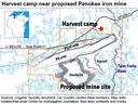
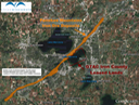
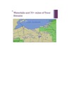
The Water's Edge
News and Views from the Water's Edge
Site Navigation
[Skip]
Save the Water's Edge (WE)
2013 Events
Videos
Update May 17 2013
Nukes and Oil Terminals
Penokee HIlls Maps
Links to informative and interesting Webpages
The Nations Speak Out - Tribal Voices
Tribal Nations in Wisconsin and Treaty Resources
The China Connection - Does this inlcude the Penokees?
LEGISLATORS in the News
GTac's Lobby at work 2010 - Present
EXPERTS REPORT - NO MINE
Views and News
Site Map
Archived Updates
A Declaration for the Great Lakes....
Penokee HIlls Maps
These are the maps of this region.
Where are the Penokees and the Bad River Watershed? Page 1
Bad River Ojibwe Homeland, Bad River Watershed, and the Penokee Hills Ore Body
Proposed Mine Site.
Waterfalls and streams at risk
What is they dug a mine?
Water on the lIne - Thanks to Carl Sack
The Threatend Steams
Threatend Streams Upclose
Copper Falls State Park is in harm's way
The Bad River as it flows through the Penokees and the Bad River Watershed
savethewatersedge@gmail.com
Updated maps of the Penokee Hills and the Bad River Watershed 01/09/12
[Back To Top]